Arizona faces 77% cut of Colorado River water as states remain deadlocked
WASHINGTON – An ongoing deadlock between the seven states that rely on the Colorado River may have dire consequences for Arizona.
A lack of agreement between the Upper and Lower Basin states would mean the federal government imposes its own plan for reallocating the water over the next 10 years – a plan that could mean cuts up to 77% for Arizona.
No other state faces such severe cuts under the “no deal” federal proposal. Nevada would see its share of the river reduced by 6%. The other five states would see no change.
For obvious reasons, Arizona has been scrambling to find an alternative.
A May 1 proposal offered by Arizona, California and Nevada calls for spreading reductions among the Lower Basin states over the next three years. The plan emphasizes voluntary cuts, and states could receive compensation from the federal government for conservation efforts.
Tom Buschatzke, director of the Arizona Department of Water Resources, said the Lower Basin states believe their proposal respects the laws and compacts that have long governed how the river is shared while also taking into account the current scarcity.
“We looked at how Lake Powell and Lake Mead would be impacted from an elevation standpoint and tried to cover as many hydrologic scenarios as possible,” he said. “It’s not a guarantee, but it’s a robust level of protection.”
The Upper Basin states – Colorado, Utah, New Mexico and Wyoming – rejected that proposal, arguing that it doesn’t reflect actual snowpack.
Those states say that both the federal and Lower Basin proposals would threaten the river’s viability and drain Lake Mead and Lake Powell to a point of catastrophic failure.
“We … have depleted the storage in those reservoirs to the brink of being empty,” said Chuck Cullom, executive director of the Upper Colorado River Commission. “We are overspending our bank account and the bank account is almost empty. So, legal theories, everyone has one. Math is indisputable.”
The one thing all states agree on is that decades of drought have pushed water levels to dangerously low levels even as demand and population grow.
“In my 25 years on the Colorado River, I haven’t seen things this bad. … We have 19th century law, 20th century infrastructure and 21st century hydrology and water demand – and it’s not lining up very well,” said Jennifer Pitt, Colorado River program director for the National Audubon Society.
The mention of 21st century hydrology refers to the decades-long megadrought afflicting the Western states that threatens to permanently alter the region’s ecosystem, disrupt the economy and disable power generation capabilities for two of the country’s most vital pieces of infrastructure: the Glen Canyon and Hoover dams.
On Wednesday, the Senate Committee on Energy and Natural Resources will hold an oversight hearing on the status of negotiations.
Risk of ‘dead pool’
The Bureau of Reclamation, part of the Department of the Interior, announced May 21 that it will spend $52 million for new turbines at Hoover Dam – turbines better suited to the historically low levels of Lake Mead.
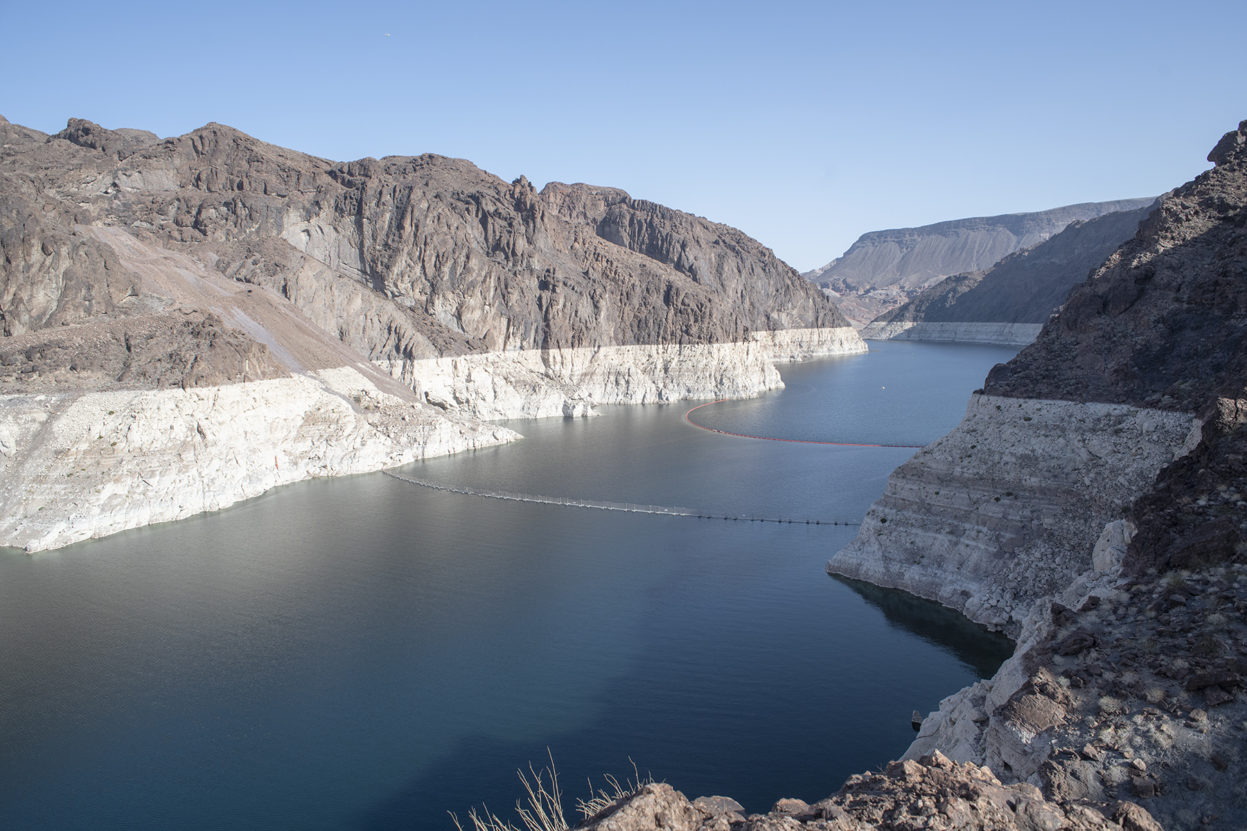
Lake Mead dropped to 1,041 feet above sea level in 2022. That’s the lowest since it first reached capacity in 1941, five years after Hoover Dam opened. The highest it’s ever been was 1,225 feet in 1983 due to a massive snowmelt. The volume was so great, engineers needed to open the dam’s spillways for the first and only time.
As of June, the lake stood at 1,048 feet. At 895 feet, it would hit “dead pool” status, which means the water is too low to flow downstream and the dam can no longer produce electricity.
Like Lake Mead, Lake Powell has experienced a steady decline since 2000, when water elevation behind the Glen Canyon Dam was approximately 3,680 feet above sea level.
That reservoir hit 3,522 feet, its all-time low, in February 2023. It is now at 3,527 feet – more than 170 feet below full capacity.
Dead pool for Lake Powell would occur at 3,370 feet.
How does Arizona get its water?
Arizona gets 36% of its water from the Colorado River, 41% from groundwater, 18% from in-state rivers and 5% from reclaimed water, according to the Arizona Department of Water Resources.
Arizona’s share of the Colorado River comes from water released from the Glen Canyon and Hoover dams.
One of Arizona’s arguments is that the Upper Basin states can tap into the river before the water even reaches Lake Powell.
What makes the situation more alarming for Arizona is the rapid depletion of its groundwater.
Between 2002 and 2024, the aquifers in the Colorado River Basin lost about 27.8 million acre-feet of groundwater, according to NASA satellite observations. That’s enough to cover 27.8 million acres of land with water 1 foot deep. And the underground reservoirs continue to decline.
The combination of dwindling supply from the river and the aquifers puts Arizona’s water security and food production at a great risk within the next decade, according to the NASA researchers.

How we got here and what’s next?
The current allocation among the seven states dates to 2007, when they cut a deal for water use that would last 19 years. The deal, which included the federal government, expires at the end of 2026.
The Bureau of Reclamation gave the states until November 2025 to present an updated deal.
When the states were unable to come to terms, the bureau issued a set of five alternative plans in January. Those plans triggered a flood of pushback, especially in Arizona.
A White House meeting in January attended by Arizona Gov. Katie Hobbs and governors of other Colorado River states failed to yield a breakthrough.
The Bureau of Reclamation intends to release an updated plan for water allocation by mid-July, with final guidelines coming in August.
Pitt isn’t optimistic about an end to the stalemate.
The most recent winter was especially dry. And “with the states poised to be fighting each other,” she said, “they don’t really have the time to be thinking about environmental concerns. They’re preoccupied with how to protect and do their jobs for their water users,” she said.
Court fights not off the table
Buschatzke cited the Colorado River Compact of 1922, which gave the Upper and Lower Basin states 7.5 million acre-feet each, asserting the Upper Basin is still obligated to release enough water to satisfy that deal.
A century ago, there were 18 million acre-feet available. Last year’s supply was just 8.5 million acre-feet, according to Bureau of Reclamation data.
The compact is a cornerstone of the Law of the River, a set of laws, treaties, compacts and court decisions dating to 1922 that dictate how much water those states and Mexico can draw.
Many experts say the Law of the River contains guidelines that have become outdated in an era of unforeseen climate change.
Upper Basin states maintain that they are not obligated to release as much water as the Lower Basin wants under the 1922 compact.
Cullom’s May 22 letter addresses some of the legal disputes and asserts that the Lower Basin proposal would not adequately protect the reservoirs.
Both sides say they are prepared to go to court.
“I believe Tom and I believe Governor Hobbs when they threaten litigation,” Cullom said. “At the same time, it doesn’t provide incentive to reach compromise on operations if one side is asserting there’s only one way to solve a problem.”
Related
![]()
Source link