These two California cities are only twenty miles apart, but the drive takes six hours
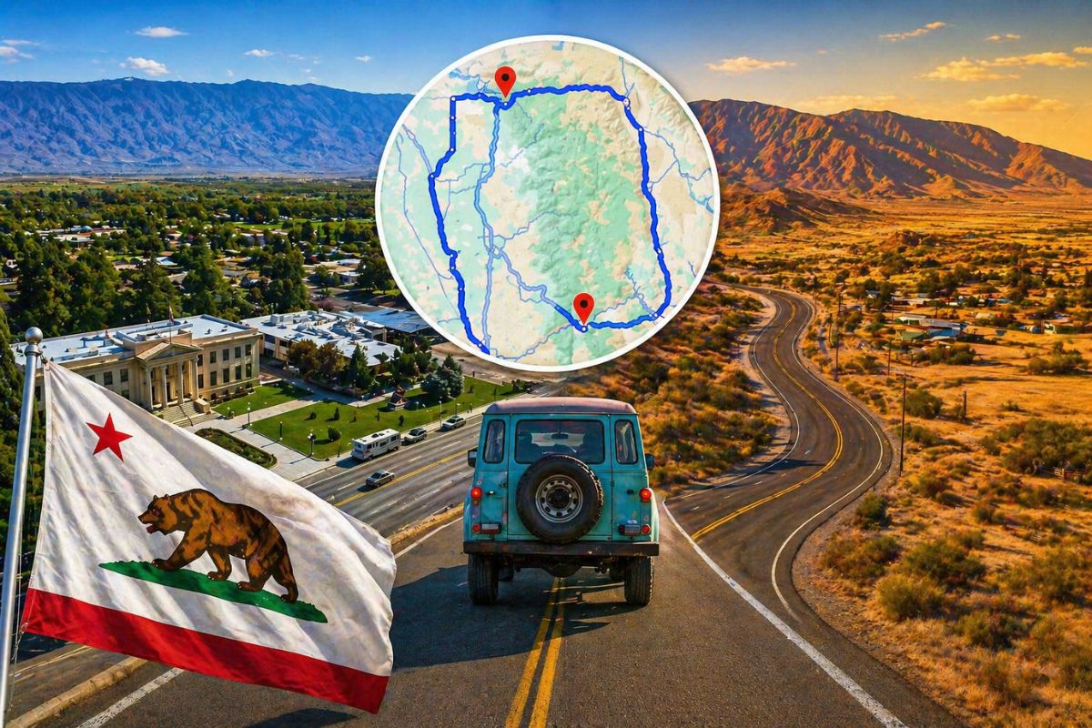
Open Google Maps and ask it to direct you from Kanawyers to Independence, California. See what happens next. The blue line is not straight. It’s not even close to straight.
It swings dramatically south through the Central Valley, skirts the edge of the Mojave Desert, loops around the bottom of one of the most formidable mountain ranges in North America and climbs back north along US Route 395 – arriving at a destination that, in a straight line, was never more than 20 miles away.
The total distance: 350 miles. Total driving time: six hours.
Welcome to one of America’s most astonishing geographic oddities—a story that’s been going viral in travel circles since early 2026, and a story that says something profound about the raw, unconquered power of California’s Sierra Nevada mountains.
The wall between them
The Sierra Nevada mountains between Kanawyers and Independence rise above 4,000 meters, including peaks such as Mount Williamson and Mount Tyndall. This portion of the range has no roads crossing it.
Mount Whitney – at 4,500 meters the highest mountain in the contiguous United States – stands almost directly between the two cities. The terrain is so vertical, so exposed and so technically demanding that engineers have never attempted to build a road across it. Not in the car age. Never.

Kanawyers is located at the end of Highway 180 in Kings Canyon National Park, tucked into the western side of the mountain range. Independence occupies the eastern side of the Sierra, a quiet seat of Inyo County in an entirely different geological world. Both towns are small. Both are beautiful. And neither has a practical direct road connection to the other.
The only way around it is the long way around it
To travel between the two cities, motorists must head west from Kings Canyon, drive through California’s Central Valley, wind south toward Bakersfield, skirt the edge of the Mojave Desert, and then climb back north along U.S. Route 395 on the eastern side of the Sierra.
It is, as one travel writer put it, “a comically long detour” – but one that reveals something remarkable about how mountains continue to shape human movement in the 21st century.
What walkers can do that drivers can’t
This is where the story gets really poetic. While a driver travels 350 miles for six hours, a backpacker with a good pair of boots and a week’s worth of food can cover the same thirty kilometers on the trail – through some of the country’s most breathtaking high Sierra wilderness.
The John Muir Trail and the Pacific Crest Trail both pass through this corridor, transporting thousands of hikers through Kings Canyon and the Inyo backcountry each year. For those willing to carry a tent, there is a “shortcut.” For everyone else, the mountains win.
Why this story is important to travelers
California’s Sierra Nevada is often experienced as a backdrop: visible from highways, photographed from vantage points, admired from a distance. The Kanawyers-Independence story forces a different kind of reckoning.
It reminds us that some geographies are never tamed. Those paths are not inevitable. That between two points that appear nearby on a map, an entire world of granite, ice and height can make the straight line completely irrelevant.
For road trip planners visiting Kings Canyon or the Eastern Sierra in 2026, this oddity has a very practical implication: don’t assume that nearby towns on either side of the area are easy day trips from each other. Check the route. Check the height. The Sierra Nevada has been humbling travelers for centuries and has no plans to stop.
Sources: Bakersfield Today, “Two California mountain towns separated by a 350-mile drive,” March 16, 2026 · Yahoo Travel, “These California towns are only 20 miles apart, but it’s a 350-mile drive,” March 17, 2026